

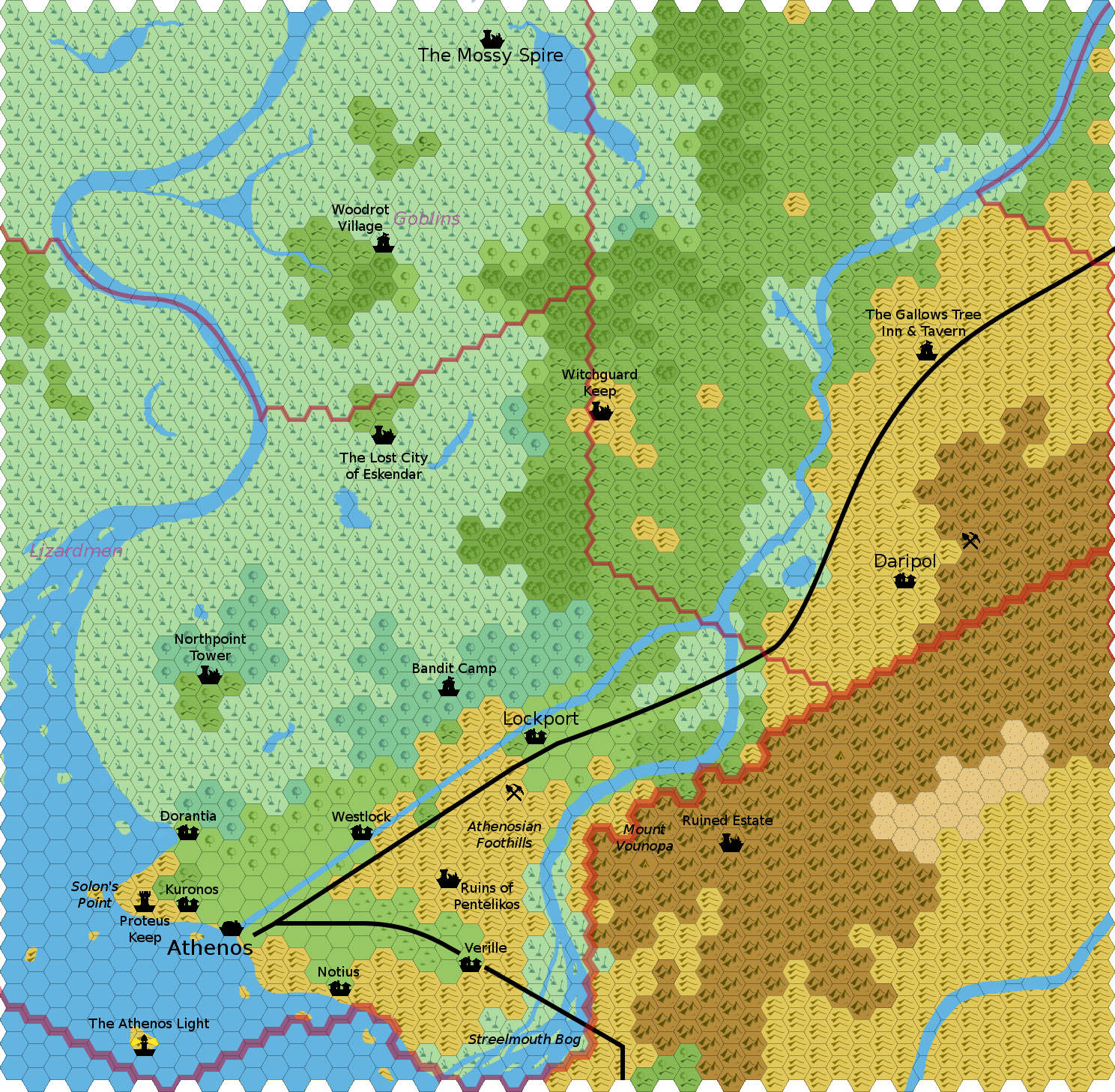
Towns
Athenos: As per Gazetteer, additional development still forthcoming.
Villages
The immediate region around Athenos is mostly farming and fishing. A few of the larger villages are noted, but they are merely representative of many such small clusters spread throughout the farmed lands.
Daripol: See 2 2/3 miles per hex map
Dorantia: Small fishing village at the edge of the swamp, probably named for a family or person. Could serve as the town in U1-U3 if one wants to set those adventures here.
Kuronos: Ancient farming village near Athenos, also works closely with Proteus Keep.
Lockport: See 2 2/3 miles per hex map
Notius: The ancient southern fishing village, foundations stretch back as far as Athenos' presence.
Verille: A modest farming village, but it also serves as the entry point to Darokin for traffic from the western part of the Five Shires. So, full of officials and plenty of caravans passing through.
Westlock: Fortified but barely garrisoned, this almost isn't a village. Staffed primarily by workers who man the locks at this end of the raised portion of the canal.
Keeps and Towers
Northpoint Tower: This tower once marked the northern portion of the city-state of Athenos' territory, but it was abandoned as the surrounding lowlands turned into swamps.
Proteus Keep: This small tower has existed long enough to have some fortifications around it. It is built on the highest hill near Solon's Point, and thus provides early warning of incursions from the north (attacks from the sea being rarer than monsters from the swamps).
Witchguard Keep: This ruined fortress may have once been the center of a domain carved out from the swamp and was probably named for the rumored witches who make their homes within the swamp. However, it's been ruins on the hill for the last hundred years.
Places of Interest
The Athenos Light: Lighthouse to both warn sailors of the rocky island upon which it sits and to guide them to the city of Athenos. Unlit in time of war, but it's been a long time since that last happened.
Bandit Camp: This small camp has housed several different bands, being well located and not easily spotted among the trees at the border of the swamp. The current band is becoming active enough that soon the merchants of Athenos will likely hire someone to root them out, since their depradations are impacting trade along the canal.
The Lost City of Eskender: The history of these ruins are lost to time, but some scholars believe the folk name (Eskender) and the myths of buried treasures and a lost civilization come from the ancient Athenosian term for dishonor or shame, and that it may mark a great defeat.
The Mossy Spire: See 2 2/3 miles per hex map
Ruined Estate: These ruins, nestled in the mountains just inside the lands of the Five Shires, may have once been an Athenosian nobleman's estate from the early years of the city (and thus before current borders and nations).
Ruins of Pentelikos: Like many of the hills around Athenos (which has existed in one form or another for a couple thousand years), this area is dotted with ruins. However, these are better preserved and more complete than most, since those in lower-lying areas have already been cannibalized for materials (such as stone) for other settlements.
Streelmouth Bog: This marshy area is where the Streel meets the Malpheggi Bay. When tensions have been higher, it's also been called the Hinbog, although those who wish to stay on good terms with the citizens of the Five Shires do not use that old name in polite company.
Woodrot Village: This is the largest settlement of the Woodrot goblin tribe, one of many goblin tribes in the area. This one has grown large enough to have been a presence for decades, though, unlike most goblin tribes which come and go.
Adventure Seeds
Lockport: (From 2 2/3 miles per hex map) It's the end of a period of very heavy traffic on the canal, and the nearby mines were shutdown briefly while the miners worked as canal labor to ease the crunch. When they returned to the mines, humanoids from the nearby swamps have taken over, in a bid to find a better base for raiding the barges on the canal.
Notes and Thoughts
A special note on the canal: this actually disagrees with the text of the Gazetteer and the 8 mph map. The Gazetteer indicates the locks are at either end of the 15-mile canal (higher than both ends), and that the Streel River is lower than Athenos Harbor (which strikes me as odd given how close Athenos and the mouth of the Streel are -- but water geography (hydrography?) isn't my area of expertise).
As I zoomed in, I put more farm land around Athenos (it's in a valley of sorts), and figured the canal most likely just runs through the hillier parts. Since it would be an even larger engineering effort to raise the whole path to one level, I figured it went up on one side of the hills, down on the other, and the rest was a "local water level" channel. So, the dug out portion works out to be about 23 miles (the canal excavated in the farmland plus the portion in the hills plus the channel dug to divert part of the Streel).