Sources:
Although it is officially the Amsorak River (both north of Lake Amsorak, and from the lake to the Arbandrine), in a previous post I changed this (for my version of Darokin).
(If I forgot anyone, it was my oversight, and I offer my apologies)
Locations:
(Anything not described below is from the Gazetteers. Anything not sourced was created for this map.)
Villages:
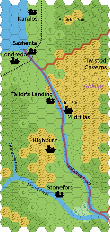
Karalos: See Akorros.
Sashenta: (name and current state from Malpheggi Swamp discussion)
Stoneford: This small farming village is old and relatively unremarkable, but it has the potential to become a regional center once the trade paths to the Atruaghin Clans are completed. As the nearest non-homestead with easy access, the villagers could very well attract quite a bit of additional traffic in the near future.
Tailor's Landing: Small stopping point just before Midrill Rock, probably part trading post, part outpost.
Keeps and Towers:
Lairs and Ruins:
Highburn: Ruins of a town or village destroyed when Irum was beaten.
Londredos: (name from Darokin History discussion, history from same thread and the Malpheggi Swamp discussion)
Midrillas: Ruins from Sashenta/Irum days.
Other Areas of Interest:
Boulder Point: See Akorros.
Midrill Rock: This small island juts up from the river bottom, thus "Mid-rill". Beyond being a marker and a potential navigation danger, it has no features of note.
Twisted Caverns: See Elstrich Valley.
Inhabitants:
(Presumably, modest numbers of humanoids in the hills, but due to traffic, probably not being particularly noisy)
Adventure Seeds:
(None from Malpheggi Swamp post)
Londredos/Sashenta: See here (excavating Londredos as part of a tourist attraction turns up a 300-year-old horror)
Closing notes:
In my view, the Sashenta River (so named by the locals, although national cartographers call it the Amsorak River) is year-round. However, the Arbandrine is more seasonal, especially in the stretch between Darokin city and Elstrich. So, the only viable water trade south of here would be via Port Tenobar. In my view, Tenobar is relatively independent, and reputable merchants do not stop there, so minimal legitimate trade goes through the port. So, trade from Sind to Akesoli mostly goes across the lake to Akorros, and overland from there. (This will likely change as trade with the Clans picks up, and as Tenobar builds itself up.)
Stoneford is poised to potentially become a serious center of trade once Atruaghin trade becomes regular.
In the meantime, the area is fairly low population south of the village of Sashenta, throuh the valley. Farming does occur in the area, and the excess is generally sold in Akorros (to the north). The middle of the valley is generally untended, and the hills and fields are probably still dotted with the ruins of the once-independent realms of Sashenta and Irum.